Multispectral Imaging Technology
|
| The DJI Mavic 3 Multispectral captures data across multiple spectral bands, essential for assessing crop health, monitoring growth, and optimizing agricultural practices by analyzing vegetation indices like NDVI and NDRE.
|
|
Precision Agriculture Flight Modes
|
| Specialized flight modes automate data collection over farmland, ensuring comprehensive coverage and consistent data gathering for effective crop monitoring.
|
|
Integrated Data Analysis Tools
|
| Powerful tools process multispectral images to provide insights into crop health, soil condition, and water needs, aiding informed decisions to improve yield and reduce resource waste.
|
|
Real-Time Data Transmission
|
| Allows immediate insights into crop conditions, facilitating quick decision-making and intervention to enhance crop management strategies.
|
|
Extended Flight Time
|
| Ensures large areas of farmland can be surveyed in a single flight, key for regular and thorough monitoring.
|
|
GPS Precision Farming
|
| Integrates GPS technology for accurate mapping, field boundary detection, and targeted treatment areas, reducing overlap and saving resources.
|
|
Enhanced Connectivity for Remote Operations
|
| Features 4G and Wi-Fi for remote operations and management, allowing operation from a distance for versatile agricultural tasks.
|
|
Weather-Resistant Design
|
| Built to withstand various environmental conditions, ensuring reliable operation in diverse climates typical of agriculture.
|
|
Portable and Easy to Deploy
|
| Compact and foldable design for easy transport and deployment across multiple fields, essential for monitoring various locations.
|
|
Global Shutter Mechanism for High-Quality Imaging
|
| Captures sharp, distortion-free multispectral images for accurate analysis, ensuring reliable data reflective of actual crop conditions.
|
|
Obstacle Avoidance System
|
| Advanced system prevents collisions with obstacles, enhancing safety during flights for both the drone and crops.
|
|
Automated Data Processing Workflow
|
| Streamlines the analysis of multispectral data, facilitating quick turnaround from data collection to actionable insights.
|
|
Seamless Integration with Farm Management Software
|
| Integrates with leading farm management software for seamless data transfer and analysis, enhancing decision-making and overall efficiency.
|
|
Free DJI Pilot 2
|
| A professional flight control app designed for enterprise drones, offering mission planning, real-time data collection, and integration with other DJI software platforms. Basic features are free, while advanced functionalities may require additional licenses.
|
|
The DJI Mavic 3 Multispectral drone is a game-changer for precision agriculture, offering advanced features tailored to the needs of modern farming. From its multispectral imaging capabilities to its durability and ease of use, it provides comprehensive solutions for monitoring, analysis, and management of crops, leading to optimized agricultural practices and improved crop yields.
* Desktop and larger screens *
.video-container {
display: flex;
gap: 20px; * Space between videos *
justify-content: space-between;
}
.video-frame {
flex: 1 1 48%; * Each video takes 48% width, leaving space for the gap *
aspect-ratio: 16 9; * Maintain aspect ratio for videos *
border: none;
}
* Mobile view *
@media (max-width: 768px) {
.video-container {
flex-direction: column; * Stack videos vertically *
}
.video-frame {
flex: 1 1 100%; * Full width on mobile *
margin-bottom: 20px; * Space between stacked videos *
}
}
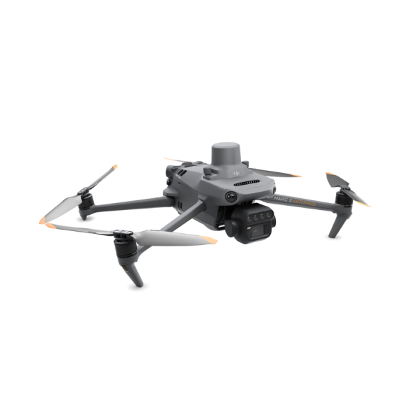
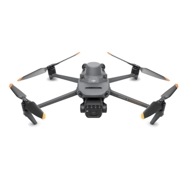
Multispectral Cameras
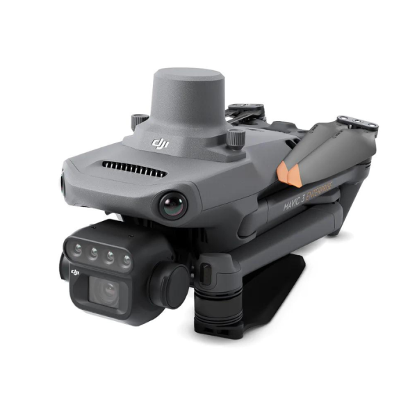
The DJI Mavic 3 Multispectral is designed for precision agriculture and environmental monitoring.
It is equipped with a multispectral imaging system that quickly captures crop growth information to achieve more effective crop production.
The Mavic 3M includes an RTK module that achieves centimeter-level positioning. The Mavic 3 Multispectral is a highly portable drone.
It’s foldable design and 951-gram weight mean it can be carried in a bag to enable farmers to carry out operations at any time.
It has 43 minutes of flight time and can complete the surveying and mapping operations of an area as vast as 2 square kilometers in a single flight.

* Desktop and larger screens *
.image-container-reversed {
display: flex;
gap: 20px; * Space between text and image *
justify-content: space-between;
align-items: flex-start; * Align the items at the top *
}
.text-container {
flex: 1 1 48%; * Text container takes up 48% of the width *
padding: 20px;
background-color: transparent; * Transparent background *
border: none;
}
.image-container-right {
flex: 1 1 48%; * Image container takes up 48% of the width *
display: flex;
justify-content: center; * Center image horizontally *
}
.responsive-image {
max-width: 100%; * Ensure image is responsive *
height: auto; * Maintain aspect ratio *
}
* Mobile view *
@media (max-width: 768px) {
.image-container-reversed {
flex-direction: column; * Stack text and image vertically on mobile *
gap: 10px; * Reduced space between stacked elements *
padding: 10px; * Add padding for mobile *
}
.text-container {
width: 100%; * Full width for text on mobile *
margin-bottom: 20px; * Space between text and image on mobile *
padding: 15px; * Adjust padding for mobile *
}
.image-container-right {
width: 100%; * Full width for image on mobile *
display: block; * Make image take full width *
padding: 15px; * Adjust padding for mobile *
}
}
RTK Module Included
Equipped with an RTK module, the Mavic 3M offers agricultural experts the ability to perform precise aerial surveys efficiently and carefully. This advanced capability eliminates the necessity for Ground Control Points, streamlining the data collection process. This makes the Mavic 3M an indispensable tool for those in agriculture seeking to enhance their surveying practices with accuracy, speed, and without the traditional reliance on ground-based markers.
The RTK module offers precision down to the centimeter, seamlessly integrating with flight control and the camera. This synchronization happens in microseconds, ensuring the exact location of the imaging center for each photo is recorded with pinpoint accuracy. This advanced feature is essential for applications requiring highly precise data, enhancing the drone’s capabilities in mapping, surveying, and other tasks where accuracy is paramount.
* Desktop and larger screens *
.image-container {
display: flex;
gap: 20px; * Space between image and text *
justify-content: space-between;
align-items: flex-start; * Align the items at the top *
}
.image-container-left {
flex: 1 1 48%; * Image container takes up 48% of the width *
display: flex;
justify-content: center; * Center image horizontally *
}
.responsive-image {
max-width: 100%; * Ensure image is responsive *
height: auto; * Maintain aspect ratio *
}
.text-container {
flex: 1 1 48%; * Text container takes up 48% of the width *
padding: 20px;
background-color: transparent; * Transparent background *
border: none;
}
* Mobile view *
@media (max-width: 768px) {
.image-container {
flex-direction: column; * Stack image and text vertically on mobile *
gap: 10px; * Reduced space between stacked elements *
padding: 10px; * Add padding for mobile *
}
.image-container-left {
width: 100%; * Full width for image on mobile *
display: block; * Make image take full width *
padding: 15px; * Adjust padding for mobile *
}
.text-container {
width: 100%; * Full width for text on mobile *
margin-bottom: 20px; * Space between text and image on mobile *
padding: 15px; * Adjust padding for mobile *
}
}
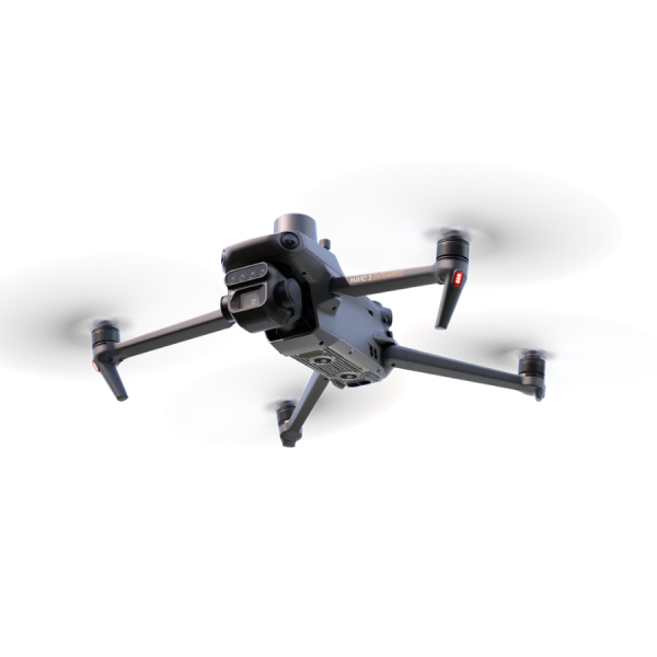
Enhanced Safety Features
Advanced Pilot Assistance System (APAS 5.0): state-of-the-art obstacle sensing and navigation. Data from six vision and two wide-angle sensors is assessed in real-time to detect obstacles in every direction and, when using Avoid mode – reroute your flight path accordingly. Advanced Return to Home: This intelligent function automatically adjusts your flight route to conserve battery power, ensuring your drone returns home securely with just a simple press. It’s designed to enhance safety and reliability by optimizing battery usage during flight. AirSense: The integrated AirSense system delivers preemptive alerts about approaching manned aircraft emitting ADS-B signals. This feature enhances safety by notifying drone operators of potential airspace conflicts, allowing for timely adjustments to avoid close encounters.
* Desktop and larger screens *
.image-container-reversed {
display: flex;
gap: 20px; * Space between text and image *
justify-content: space-between;
align-items: flex-start; * Align the items at the top *
}
.text-container {
flex: 1 1 48%; * Text container takes up 48% of the width *
padding: 20px;
background-color: transparent; * Transparent background *
border: none;
}
.image-container-right {
flex: 1 1 48%; * Image container takes up 48% of the width *
display: flex;
justify-content: center; * Center image horizontally *
}
.responsive-image {
max-width: 100%; * Ensure image is responsive *
height: auto; * Maintain aspect ratio *
}
* Mobile view *
@media (max-width: 768px) {
.image-container-reversed {
flex-direction: column; * Stack text and image vertically on mobile *
gap: 10px; * Reduced space between stacked elements *
padding: 10px; * Add padding for mobile *
}
.text-container {
width: 100%; * Full width for text on mobile *
margin-bottom: 20px; * Space between text and image on mobile *
padding: 15px; * Adjust padding for mobile *
}
.image-container-right {
width: 100%; * Full width for image on mobile *
display: block; * Make image take full width *
padding: 15px; * Adjust padding for mobile *
}
}
Smart Terrain Follow
The Mavic 3M offers Terrain Follow, helping you maintain an even altitude as you fly a survey mission across varying terrain.
By seamlessly adapting to changes in terrain during flight, the system ensures the accuracy and integrity of collected data, eliminating the need for adjustments during post-processing. This approach not only streamlines the data acquisition process but also enhances the quality of the information gathered, providing reliable and precise outcomes without the necessity for later corrections. Such efficiency is crucial for professionals who rely on accurate data for analysis and decision-making.
In scenarios where importing a Digital Surface Model (DSM) or local elevation data before flight isn’t possible, the Mavic 3M’s advanced collision avoidance sensors step in. These sensors actively scan the terrain beneath the drone, automatically modifying its flying altitude to adapt to the ground’s undulations. This ensures a safer flight by preventing potential collisions with the earth, highlighting the drone’s ability to navigate complex environments without pre-loaded elevation information.
* Desktop and larger screens *
.image-container {
display: flex;
gap: 20px; * Space between image and text *
justify-content: space-between;
align-items: flex-start; * Align the items at the top *
}
.image-container-left {
flex: 1 1 48%; * Image container takes up 48% of the width *
display: flex;
justify-content: center; * Center image horizontally *
}
.responsive-image {
max-width: 100%; * Ensure image is responsive *
height: auto; * Maintain aspect ratio *
}
.text-container {
flex: 1 1 48%; * Text container takes up 48% of the width *
padding: 20px;
background-color: transparent; * Transparent background *
border: none;
}
* Mobile view *
@media (max-width: 768px) {
.image-container {
flex-direction: column; * Stack image and text vertically on mobile *
gap: 10px; * Reduced space between stacked elements *
padding: 10px; * Add padding for mobile *
}
.image-container-left {
width: 100%; * Full width for image on mobile *
display: block; * Make image take full width *
padding: 15px; * Adjust padding for mobile *
}
.text-container {
width: 100%; * Full width for text on mobile *
margin-bottom: 20px; * Space between text and image on mobile *
padding: 15px; * Adjust padding for mobile *
}
}
Intelligent Field Scouting
The Mavic 3M can carry out automatic field scouting. The field scout images can be uploaded to the DJI Smart Farm Platform in real time through a 4G network.
It can find abnormalities, such as emergence deficiencies, weed pressure, and crop lodging, in a timely manner.
Equipped with AI identification capabilities, the system excels in intelligent analyses like cotton seedling detection and rice yield assessments. This allows for the real-time exchange of vital crop growth data, provides actionable insights for farming operations, and streamlines the management process, enabling a single individual to efficiently oversee up to 70 hectares of agricultural land. Through advanced AI applications, it revolutionizes agricultural practices by enhancing productivity and simplifying large-scale farm management.
* Desktop and larger screens *
.image-container-reversed {
display: flex;
gap: 20px; * Space between text and image *
justify-content: space-between;
align-items: flex-start; * Align the items at the top *
}
.text-container {
flex: 1 1 48%; * Text container takes up 48% of the width *
padding: 20px;
background-color: transparent; * Transparent background *
border: none;
}
.image-container-right {
flex: 1 1 48%; * Image container takes up 48% of the width *
display: flex;
justify-content: center; * Center image horizontally *
}
.responsive-image {
max-width: 100%; * Ensure image is responsive *
height: auto; * Maintain aspect ratio *
}
* Mobile view *
@media (max-width: 768px) {
.image-container-reversed {
flex-direction: column; * Stack text and image vertically on mobile *
gap: 10px; * Reduced space between stacked elements *
padding: 10px; * Add padding for mobile *
}
.text-container {
width: 100%; * Full width for text on mobile *
margin-bottom: 20px; * Space between text and image on mobile *
padding: 15px; * Adjust padding for mobile *
}
.image-container-right {
width: 100%; * Full width for image on mobile *
display: block; * Make image take full width *
padding: 15px; * Adjust padding for mobile *
}
}
Mavic 3E Customisation
Build a solution tailored to your needs with Cloud API and MSDK.
Cloud API
The Mavic 3M can be directly connected to a third-party cloud platform via Pilot 2’s built-in DJI Cloud API based on the MQTT protocol. There is no need to develop an app separately to enable the transmission of UAV equipment information, live streaming, photo data, and other information.
MSDK
The Mavic 3M supports Mobile SDK 5 (MSDK5) with a fully open-source production code sample. The MSDK5 makes it possible to develop a proprietary control app for UAV field patrol, smart surveying, and other scenarios, making it more user-friendly.
* Desktop and larger screens *
.image-container {
display: flex;
gap: 20px; * Space between image and text *
justify-content: space-between;
align-items: flex-start; * Align the items at the top *
}
.image-container-left {
flex: 1 1 48%; * Image container takes up 48% of the width *
display: flex;
justify-content: center; * Center image horizontally *
}
.responsive-image {
max-width: 100%; * Ensure image is responsive *
height: auto; * Maintain aspect ratio *
}
.text-container {
flex: 1 1 48%; * Text container takes up 48% of the width *
padding: 20px;
background-color: transparent; * Transparent background *
border: none;
}
* Mobile view *
@media (max-width: 768px) {
.image-container {
flex-direction: column; * Stack image and text vertically on mobile *
gap: 10px; * Reduced space between stacked elements *
padding: 10px; * Add padding for mobile *
}
.image-container-left {
width: 100%; * Full width for image on mobile *
display: block; * Make image take full width *
padding: 15px; * Adjust padding for mobile *
}
.text-container {
width: 100%; * Full width for text on mobile *
margin-bottom: 20px; * Space between text and image on mobile *
padding: 15px; * Adjust padding for mobile *
}
}
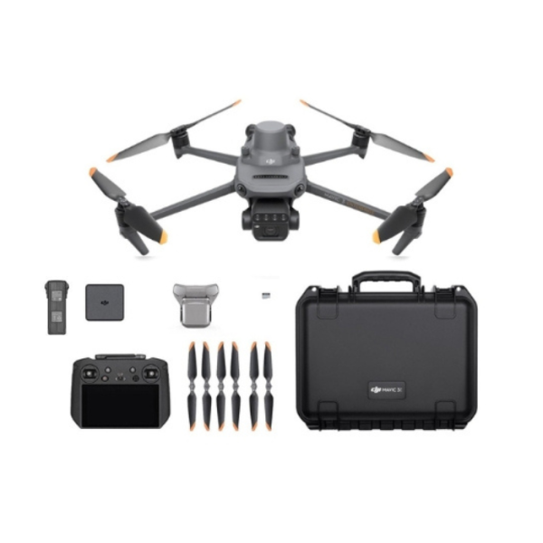
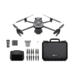
In The Box
Full Software Suite
The Mavic 3 Multispectral is fully compatible with the DJI SmartFarm app, allowing agriculture professionals to coordinate any data gathered with spraying and spreading operations. SmartFarm comes with a range of features for streamlined workflows, including intuitive mission planning, a full fleet overview, field management, data assessment, and effortless collaboration between teams. Data captured by Mavic 3M is also fully compatible with DJI Terra, so you can easily and efficiently create maps and models of your targets. The Mavic 3M comes with a three-month DJI Terra Full licence (one device) and one-year access to the DJI SmartFarm Platform.
Package Includes :
- 1x DJI Mavic 3 Multispectral Aircraft (with propellers)
-
- 1x RTK Module
-
- 1x Micro SD Card
-
- 1x DJI Mavic 3 Enterprise Battery
-
- 1x RC Pro Enterprise Remote Controller
-
- 3x Spare Propeller Pair
-
- 1x Charger
-
- 1x Carrying Case
-
- 1x USB-C to USB-C Cable
-
- 1x Power Cable
-
- 1x USB-C Cable
-
- 1x Screwdriver
-
- 1x Manuals
-
- 1x DJI Care Enterprise Basic, 1-Year
-
Specification:
| Aircraft
|
|
| Net Weight (with propellers and RTK module) [1]
|
|
| 951 g
|
|
|
|
|
|
|
|
| Max Takeoff Weight
|
|
|
|
|
|
|
|
1,050 g
|
|
|
|
|
|
|
|
| Dimensions (Folded Unfolded)
|
|
|
|
|
|
|
|
Folded (without propellers)
|
| 223×96.3×122.2 mm (Length×Width×Height)
|
|
|
|
|
|
| Unfolded (without propellers)
|
| 347.5×283×139.6 mm (Length×Width×Height)
|
|
|
|
| Diagonal Length
|
|
|
|
|
|
|
|
Diagonal
|
| 380.1 mm
|
|
|
|
|
|
| Max Ascent Speed
|
|
|
|
|
|
|
|
6 m s (Normal Mode)
|
|
|
|
|
|
|
|
| 8 m s (Sport Mode)
|
|
|
|
|
|
|
|
| Max Descent Speed
|
|
|
|
|
|
|
|
6 m s (Normal Mode)
|
|
|
|
|
|
|
|
| 6 m s (Sport Mode)
|
|
|
|
|
|
|
|
| Max Flight Speed (at sea level, no wind)
|
|
|
|
|
|
|
|
15 m s (Normal Mode)
|
|
|
|
|
|
|
|
| Flying forward
|
| 21 m s, flying sideways
|
| 20 m s, flying backwards
|
| 19 m s (Sport mode) [2]
|
|
| Max Wind Speed Resistance
|
|
|
|
|
|
|
|
12 m s [3]
|
|
|
|
|
|
|
|
| Max Take-off Altitude Above Sea Level
|
|
|
|
|
|
|
|
6000 m (without a payload)
|
|
|
|
|
|
|
|
| Max Flight Time (without wind)
|
|
|
|
|
|
|
|
43 minutes [4]
|
|
|
|
|
|
|
|
| Max Hover Time (without wind)
|
|
|
|
|
|
|
|
37 minutes [4]
|
|
|
|
|
|
|
|
| Max Flight Distance
|
|
|
|
|
|
|
|
32 km [6]
|
|
|
|
|
|
|
|
| Max Tilt Angle
|
|
|
|
|
|
|
|
30° (Normal Mode)
|
|
|
|
|
|
|
|
| 35° (Sport Mode)
|
|
|
|
|
|
|
|
| Max Angular Velocity
|
|
|
|
|
|
|
|
200° s
|
|
|
|
|
|
|
|
| GNSS
|
|
|
|
|
|
|
|
GPS + Galileo + BeiDou + GLONASS (GLONASS is supported only when RTK module is enabled)
|
|
|
|
|
|
|
|
| Hovering Accuracy Range
|
|
|
|
|
|
|
|
Vertical
|
| ±0.1 m (Vision Positioning enabled); ±0.5 m (GNSS Positioning enabled); ±0.1 m (D-RTK enabled)
|
|
| Horizontal
|
| ±0.3 m (Vision Positioning enabled); ±0.5 m (HD Positioning enabled); ±0.1 m (RTK enabled)
|
|
| Operating Temperature
|
|
|
|
|
|
|
|
-10° to 40° C (14° to 104° F)
|
|
|
|
|
|
|
|
| Internal Storage
|
|
|
|
|
|
|
|
N A
|
|
|
|
|
|
|
|
| Motor Model Number
|
|
|
|
|
|
|
|
2008
|
|
|
|
|
|
|
|
| Propeller Model Number
|
|
|
|
|
|
|
|
9453F Enterprise Edition
|
|
|
|
|
|
|
|
| Light Sensor
|
|
|
|
|
|
|
|
Built-in module
|
|
|
|
|
|
|
|
RGB Camera
|
|
|
|
|
|
|
|
Image Sensor
|
|
|
|
|
|
|
|
4 3 CMOS
|
|
|
|
|
|
|
|
| Effective Pixels
|
| 20 MP
|
|
|
|
|
|
| Lens
|
|
|
|
|
|
|
|
FOV
|
| 84°
|
|
|
|
|
|
| Equivalent focal length
|
| 24 mm
|
|
|
|
|
|
| Aperture
|
| f 2.8 to f 11
|
|
|
|
|
|
| Focus
|
| 1 m to ∞
|
|
|
|
|
|
| ISO Range
|
|
|
|
|
|
|
|
100-6400
|
|
|
|
|
|
|
|
| Shutter speed
|
|
|
|
|
|
|
|
Electronic shutter
|
| 8-1 8000 s
|
|
|
|
|
|
| Mechanical shutter
|
| 8-1 2000 s
|
|
|
|
|
|
| Max Image Size
|
|
|
|
|
|
|
|
5280×3956
|
|
|
|
|
|
|
|
| Photo Shooting Mode
|
|
|
|
|
|
|
|
Single shot
| 20 MP
|
|
|
|
|
|
| Timelapse
|
| 20 MP | | | | | | | | | | | | | | | | | | | | | | | | | | | | | | | | | | | | | | | | | | |